


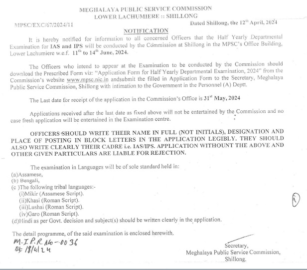


SHILLONG, MAR 21: Meghalaya Deputy Chief Minister Roytre C Laloo today informed the Assembly that the 2009 Map was published by the Survey of India and not by the Geological Survey of India with a caveat that the inter-state boundary with Assam was yet to be verified.
Laloo was replying to a motion moved by opposition HSPDP legislator Phlastingwell Pangniang who alleged that the 12 areas of difference are missing from the Meghalaya Map issued by the Geological Survey of India (GSI) in 2009.
Pangniang also demanded the state government to immediately obtain the corrected Map.
Leader of Opposition Donkupar Roy suggested the need to adopt a similar system of “Pakistan occupied Kashmir (POK)” in the Indian Map by ensuring all areas of difference should be marked with different colours.
However, the deputy chief minister while commenting that the discussion is on something which does not exist informed that the state government had officially written to the GSI for supply of the 2009 Map.
He said that the reply received from the GSI clearly states – “This is to inform you that the GSI North Eastern Region did not publish any official map of Meghalaya in 2009”.
Laloo further clarified that the 2009 Map referred to by the member and also available with the government is the one published by the Survey of India, Department of Science and Technology, Government of India (Uttarakhand).
The Survey of India had published the first edition of the state map series of Meghalaya in 2009. However, this Map showed only 7 districts of the state and did not include the 12 areas of difference with Assam as claimed by Meghalaya.
It was also stated that when a Map is being prepared by the Survey of India, the state government and district administrations are always consulted for verification and authentication.
“However, publication of the map series 2009 was done without consent of the state government and district administrations which mean that there was no consultation,” Laloo said.
Stating the government has strongly objected to the publication of the Map, he said they have sought clarification from the Additional Surveyor General Survey of India, Shillong as to why areas of difference were not included.
The Additional Surveyor General Survey of India clarified that the state map as published in 2009 inter-state boundary between Assam and Meghalaya as shown is according to North Eastern Area Reorganization Act, 1971.
Taking the clarification seriously, he said that the state government instructed that the Map should carry a caveat or a remark that inter-state boundary with Assam is yet to be verified in view of the sensitivity that it involves.
After objection from the state government, Laloo said the Survey of India accordingly rectified and carry a caveat which read – “Inter-State boundary with Assam is yet to be verified”.


+ There are no comments
Add yours